This post will show you a San Francisco sightseeing itinerary by car. As distances are long in San Francisco, driving is by far the best way to explore the city.
No need to worry about driving in Central San Francisco. It’s super easy, yet its best to visit on a Saturday or Sunday when there is less traffic. Parking, however, may cause problems, but we found good solutions for that which I will share.
We spent a sunny Saturday driving around Central San Francisco and on Sunday we explored the Golden Gate area. Both days were fantastic and the natural beauty of the hilly metropolis surprised us.
There was a lot more to see than we had thought, coming from Europe and being fist time visitors.

San Francisco sightseeing: Alamo Square
So we did all our San Francisco sightseeing by car, but you can use public transport as well to get to the same places. That way it will only take more time and you will have to examine San Francisco bus and cable car maps and timetables.
San Francisco has well developed public transport and many connections. You just need to buy a day ticket at a kiosk (something like USD 20) and having that you are free to use buses, streetcars and old San Francisco cable cars for a day.
But now about our trip.
San Francisco Sightseeing Itinerary
San Francisco by car: driving itinerary on the map
Here you can see our San Francisco driving itinerary marked on a Google map. You can zoom in and out the map and use it as your guidance when driving.
We entered San Francisco from the freeway from the downtown exit (Fremont Street). After driving a long while up and down the incredibly steep hills (yes, they are steep) we left the car for a few hours in a parking garage (Beach Street close to Pier 39 on the map) and explored the Fisherman’s Wharf area by foot. Beach Street garages had very reasonable parking rates and they had flat rates for the whole day on a Saturday.
There are apps and websites with up to date information on parking spaces and rates. These handy tools helped us find where to park. Below are links to a few that might be helpful, and look for more on Google.
Online information on parking in San Francisco
Another provider of parking information in San Francisco
Downtown San Francisco

San Francisco skyscrapers
So we started with downtown San Francisco. After driving down from the freeway we got into a deep gorge with super high skyscrapers on both sides.
San Francisco Financial District
The Financial District of San Francisco has changed a lot since the Gold Rush when this place already was a base for trade functions. At that time the business people were miners that came here to weigh their gold and get a quote on it.
Driving through Downtown San Francisco
On weekdays the Financial District is hectic but on weekends there’s – simply nobody. It’s easy to find parking space and have an urban walk in the deep shady canyons protected from all sunshine. Looking upwards you will see how high these earthquake protected buildings are!
San Francisco Sightseeing: Market Street

The old-style Market Street of San Francisco
Market Street is the main street that cuts through Downtown San Francisco, running from the Ferry Building to the Powell Street Cable Car Turntable.
Lined with low historic buildings this leafy alley is very different from the deep canyons all around it. Market Street rather looks like a European high street.
This is where most department stores are, making the San Francisco Market Street one of the main shopping streets of the city.
San Francisco sightseeing: Market Street in photos
Powell Street Cable Car Turntable

Cable car turning at the Powell Street cable car turntable
From the Powell Street cable car end stop you can take the cable car and travel to the Chinatown, Nob Hill and all the way to the other side of the hill where the Fisherman’s Wharf is. If you want to travel, simply pay the conductor. Cable car conductors also sell day passes.
This is the end stop where two cable car lines, the Powell-Mason and Powell-Hyde lines turn back, so just set yourself in the queue and wait for the next cable car to come.
San Francisco Ferry Building

San Francisco by car: the old Ferry Building
At the other end of Market Street is the old Ferry Building. This was the main entry point to the city until two bridges, the Golden Gate Bridge and the Bay Bridge, were opened.
San Francisco has water on three sides so you can imagine how useful the bridges were – and still are.

Alcatraz, the historic prison island of San Francisco
Despite the bridges there’s still a lot of ferry traffic on the bay. You can take a ferry to Sausalito and Tiburon north of the bay, or to Oakland and Vallejo in the east.
There are also ferries to the historic Alcatraz Island, leaving from another terminal further north.
Chinatown San Francisco

A main street facade in Chinatown San Francisco
Chinatown is like a piece of China on the steep slopes of San Francisco.
This is Grant Avenue, the Chinatown’s main street. The busy street begins at the “Dragons’ Gate” and you will find loads of Chinese restaurants on the main street and even more on the side streets:
San Francisco Chinatown in photos
On the nearby Kearny Street the Chinese community of San Francisco gathers for Chinese music and games.

Weekend in a Chinese park
Looking at them you could imagine being in China. Fantastic how people keep up their traditions!
California Street

Driving behind a San Francisco cable car
From Chinatown we took California Street up to Nob Hill.
California Street is so steep that it was almost too exiting for us to drive behind a cable car, stopping each time it stopped and starting uphill again each time it started. Street corner after street corner.

A cable car stopping to take passengers
Streets like this would never work in Europe where a lot of cars still have manual gears. With an automatic car it’s easier…
However, in some way we did manage to get up California Street (and all other streets)! – And very soon we got used to driving up and down San Francisco hills.
Nob Hill and Russian Hill

Cable car going down from Nob Hill
Nob Hill, the highest summit of central San Francisco, is our next destination. Nob Hill looks like a wealthy area, which it is.
It started when wealthy families started building their houses up on the hill after the cable car line was opened. The new cable car line provided easy access to the hill.

Testing the San Francisco cable car

Cable cars on Nob Hill and Russian Hill
Later the 1906 earthquake took much of Nob Hill after which the wealthy house owners moved west to Pacific Heights and built their homes there.
However, Nob Hill was rebuilt and today it’s a place where upper class families and urban professionals like to live. And why not? Nob Hill and the next hill, Russian Hill, have splendid views to the city and to the bay area:

A San Francisco city tour on Russian Hill
Drive to the summit of Russian Hill and you will find the street said to be the crookedest street in the world:
San Francisco Sightseeing: Lombard Street

Lombard Street is the steepest street in San Francisco
Even when the Americans insist on driving up and down the steep 44 San Francisco hills, one street turned out too steep even to them.
Lombard Street was so steep that it needed eight turns to make it drivable:

San Francisco by car: driving down the eight turns of Lombard Street
To make driving easier, the most curved section of Lombard Street was made a one-way street (only down), and there is a strict speed limit (5 mph, 8km/hour).
The curves enable driving down but the turns are too sharp for any longer cars and buses.
San Francisco sightseeing: driving down Lombard Street
Lombard Street twists down past green bushes and flower beds. If you’re not driving, use the steps for walkers that exist on both sides.

Walking up and down Lombard Street
Driving down Lombard Street was great fun and we had to do it twice, and then walk one more time. Recommend!
How to get to Lombard Street if you’re not driving: take the Powell-Hyde cable car. It stops at the top of the curved block and you can walk down the stairs and see the cars.
Fisherman’s Wharf

Fisherman’s Wharf, a fishing harbor
From Lombard Street it’s a short drive down to the North Shore of San Francisco and to Fisherman’s Wharf. Fisherman’s Wharf was and still is a fishing harbor, but its new main focus has changed from fishing industry to tourism industry.

Colorful Fisherman’s Wharf flowers
Fisherman’s Wharf is known for its seafood restaurants (that exist in all price classes), cafes, shops, museums and other typical tourist attractions. Ferry cruises to the bay also start here.
The tourist area of San Francisco’s Fisherman’s Wharf
So most old harbor buildings have been transformed to restaurants and shopping malls. Not bad, both tourists and locals like this. And I like the pretty flower beds in between.

More flowers making the are attractive
Fisherman’s Wharf Pier 39

Pier 39, San Francisco
What all nature lovers come here for is the Pier 39 with colonies of barking Californian sea lions. The sea lions settled here after the 1989 earthquake when they had to escape from somewhere else and since that they have increased in number.
To get to the end of the pier where the sea lions are you will need to walk all the way through the tourist zone, souvenir shops and carousels. By the way, the carousel below has two levels:
Pier 39, a tourist place
Pier 39 is always packed with people and unlike elsewhere in the city, has a good choice of restaurants where to have lunch.


Many popular seafood restaurants
But the main thing here are the sea lions:
San Francisco Pier 39 Sea Lions

Pier 39 sea lions basking in the sun
Here they are, San Francisco sea lions, basking on the docks. Lying in the sun side by side and diving into the waters when they get hungry.
The place at the end of Pier 39 is just perfect for these water mammals, there is a lot of food in the water and the bay is sheltered from all winds and waves. The sun heats the air and the seals have their dear friends and neighbors around them :).

Friends and neighbors sunbathing
The number of Pier 39 sea lions varies along the year, the record number of seals present at the same time being 1700.
Most San Francisco seals travel south in summer to give birth to their pups and to be back here for winter. This means only a small number of sea lions stay here throughout the year.

Two California sea lions making a noise
California sea lions are noisy, they bark and they smell. Despite that they look really cute, social and intelligent. You definitely have to include Pier 39 in your San Francisco sightseeing program.
Now we could get back to the hills, to Pacific Heights:
Pacific Heights

Victorian houses of Pacific Heights
From the harbor it’s an easy drive to our next San Francisco destination. The residential area of Pacific Heights is on the next hill in order and offers great views to the city and the bay area.
Pacific Heights surprised us: all streets are lined with old-style Victorian homes. Easy to tell that this is an exclusive neighborhood.
The exclusive neighborhood on Pacific Heights
To start exploring the Victorian quarters, first drive around Lafayette Park that has rows of pretty Victorians on all four sides.
Then take Washington Street towards the next park in the west, Alta Plaza. The streets here are so quiet and leafy that you couldn’t imagine this is in a huge metropolis.

San Francisco by car: Pacific Heights building style
After you’ve seen enough of Pacific Heights, turn south to see a totally different neighborhood.
Our next San Francisco sight: the hippie suburb Haight Ashbury.
Haight Ashbury

Summer of Love in Height Ashbury, San Francisco
Haight Ashbury got its name from the corner of its two major streets, Haight and Ashbury. Like Pacific Heights and Nob Hill, Haight Ashbury consists of large Victorian houses – but that’s the only similarity.
Haight Ashbury has another kind of history. In the 1960’s the traditional middle-class residential area suddenly became the hotspot of the Flower Power generation.
The heyday of the Haight was the 1967 Summer of Love when thousands or young California dreamers flocked to the place and filled all quarters.
Typical views of the old hippie district
Finally something like 100 000 hippies from all over the States and abroad gathered in Haight and the nearby parks of Panhandle and Golden Gate. Many of their idols like Jimi Hendrix were living here at that time and rock music was heard and hippie art seen in all places.
After some years the movement faded and the area decayed, but Haight Ashbury still retains much of its hippie atmosphere.

Haight Ashbury, San Francisco
Today Haight Ashbury is a vibrant area with second-hand shops, cafes, bars and music shops. It still has an appeal and is well worth visiting when you are exploring San Francisco by car.
San Francisco by car: Haight Ashbury
Haight Ashbury is one of the places that made San Francisco world famous and represents for the people of that time the “real old” San Francisco Yet it’s good to know that today Haight Ashbury is an area with severe crime and drug problems. So you need to watch up when walking here.
San Francisco Sightseeing: Alamo Square

San Francisco sightseeing by car: Alamo Square
Not far away from Haight Ashbury comes the place where we will end our San Francisco sightseeing tour for today.
Alamo Square has nice sets of Victorian houses, one of which is the famous postcard row that probably is the most photographed spot in all San Francisco. These houses called the “Painted Ladies” can be seen on San Francisco postcards.

Alamo Square, San Francisco
To get the best views of the painted ladies come here in the evening and look at them from the Alamo Square Park. In the evening when the sun shines on the painted ladies from the west it makes them shine.
The painted ladies at the top of San Francisco hills
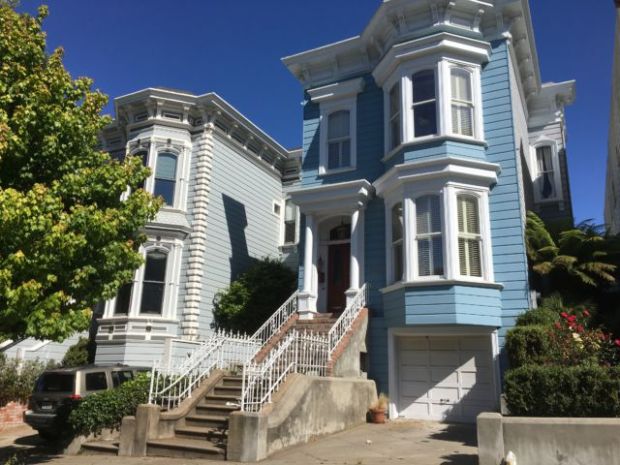
Yet the Painted Ladies are not the only houses like that in the big city, there are Victorian houses all over San Francisco. Totally 14 000 Victorians have been saved in the city after all earthquakes and fires that have destroyed a lot of the city, time after time.

A San Francisco Victorian house
These pretty Victorian houses together with bay views from the 44 hills make San Francisco what it is. How many people know what San Francisco is like? It’s like this, and will be.
Next Post: Golden Gate Area Sights

The San Francisco Golden Gate Bridge
Our next post will show you more about San Francisco as we will go and see the Golden Gate Bridge and more Golden Gate area sights.
More on California Travel
More California posts that might also interest you:
Explore San Francisco:
San Francisco day trips:


